Essential Techniques for Accurate Boundary Surveys
Table Of Contents
The Survey Process Explained
Boundary surveys are vital for determining property lines and establishing legal ownership of land. The process begins with gathering historical records, which may include land titles, previous survey data, and any existing easements or encroachments. This information helps surveyors understand the property’s context and ensure accuracy as they move forward.
Fieldwork is a significant phase of boundary surveying. This involves physically measuring the land using advanced equipment such as total stations and GPS devices. Surveyors mark the property boundaries through precise calculations and careful observation. Once the fieldwork is completed, surveyors compile their findings into detailed maps and reports, which outline the boundaries and provide a clear picture of the property’s dimensions.
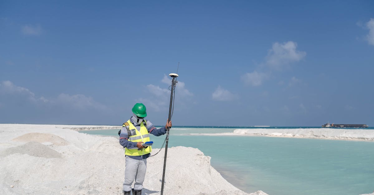
Step-by-Step Guide to Conducting a Survey
The initial phase involves thorough research into the property’s history and existing documentation. It is essential to gather all available information regarding land titles, previous surveys, and easements that might affect the boundaries. Visiting local council offices and engaging with Property and Land Information (PLI) services can provide necessary data to support your survey.
Once the research is complete, the actual surveying can begin. This often starts with establishing reference points or benchmarks that will guide the survey. High-precision instruments like the Total Station or GPS equipment are used to measure angles and distances accurately. Throughout the process, maintaining detailed records of observations and measurements is crucial for the integrity of the results.
Common Challenges in Boundary Surveys
Boundary surveys often face various challenges, primarily related to the accuracy of existing records. Discrepancies in historical documentation can lead to conflicts and misunderstandings. In many cases, property boundaries may not align with what is marked on the ground, creating tension between neighbouring property owners. Surveyors must carefully navigate these inconsistencies, which may require extensive research and consultation with local authorities.
Environmental factors can further complicate the survey process. Dense vegetation, rugged terrain, or waterways can obstruct visibility and access to specific boundary markers. Adverse weather conditions may also pose delays, impacting the timeline and planning. These challenges demand a combination of technical skills and practical problem-solving abilities, underscoring the importance of thorough preparation and adaptability during the surveying process.
Navigating Environmental and Legal Obstacles
Boundary surveys often face various environmental challenges that can complicate the process. Natural features such as rivers, wetlands, and dense vegetation may obscure required markers or interfere with measurements. Special care must be taken to comply with environmental regulations when working in sensitive areas. Surveyors may need to engage with local environmental authorities to ensure that the survey does not disrupt ecosystems or violate conservation laws.
Legal challenges also play a significant role in boundary surveys. Disputes over land ownership can lead to complex legal situations. Land titles, easements, and zoning regulations impact the survey's accuracy and feasibility. Engaging legal counsel who is familiar with property law can be beneficial, especially in areas where legal disputes are common. Clear documentation and an understanding of historical land uses will aid in navigating these obstacles effectively.
Hiring a Professional Surveyor
Selecting a qualified professional surveyor can greatly impact the quality and accuracy of your boundary survey. Start by assessing their credentials. Look for someone with relevant qualifications and membership in professional bodies like the Surveying and Spatial Sciences Institute (SSSI). Experience in local land regulations and knowledge of regional surveying practices are also critical. A surveyor who understands the nuances of your specific area will navigate the process more efficiently.
It is also beneficial to seek recommendations from peers or other industry professionals. Evaluating a surveyor’s previous work through client references can provide insight into their reliability and expertise. Additionally, while cost is a consideration, the lowest bid does not always equate to the best service. Consider their reputation, the technology they use, and their approach to communication throughout the surveying process. Ensuring clarity and professionalism will help establish a smooth collaboration.
What to Look for in a Qualified Expert
When seeking a qualified surveyor, it is essential to assess their credentials and experience in the field. Look for licensure and certifications that demonstrate proficiency in boundary surveying. An expert should be familiar with local regulations and possess a solid understanding of land laws relevant to your specific area. Experience in similar projects can also indicate the surveyor’s ability to handle your requirements efficiently, ensuring that they are well-versed in potential challenges that may arise during the survey process.
Additionally, consider the surveyor’s reputation and client feedback. Reviews and testimonials from previous clients can provide insights into their professionalism, communication skills, and overall performance. A trustworthy surveyor will offer a clear explanation of their processes, be transparent about costs, and maintain open lines of communication throughout the project. Choosing someone who prioritises client satisfaction can lead to a smoother experience and more reliable results.
FAQS
What is a boundary survey?
A boundary survey is a process used to determine the exact location of property lines and corners, providing a clear understanding of land boundaries for legal, construction, or real estate purposes.
How long does a boundary survey typically take?
The duration of a boundary survey can vary depending on the size and complexity of the property, but it typically takes anywhere from a few hours to several days to complete.
What tools are commonly used in boundary surveys?
Common tools used in boundary surveys include theodolites, total stations, GPS units, levels, and measuring tapes to ensure accuracy in measuring distances and angles.
What are some common challenges faced during boundary surveys?
Common challenges include navigating environmental obstacles, resolving disputes over property lines, and dealing with outdated or inaccurate property records.
Why is it important to hire a professional surveyor?
Hiring a professional surveyor ensures that the survey is conducted accurately and in compliance with legal requirements, which can help avoid potential disputes and costly mistakes in the future.
Related Links
Common Challenges Faced in Boundary Surveys in GeelongInnovations in Boundary Surveying Practices
The Process of Reviewing Boundary Survey Documentation
A Guide to Understanding Survey Marks and Their Significance
How Boundary Surveys Protect Against Property Disputes
Best Practices for Landowners Regarding Boundary Surveys